Ohio, sometimes known as the Buckeye State (after the Ohio buckeye tree), is one of the most populous states in the United States. This northern state borders Lake Erie to the north and is around the same latitude as northern California and Utah.
Much of Ohio is classified as plain or plateau, with enormous expanses of flat territory dominating all except the southern section of the state. The Appalachian Plateau includes the southeastern portion, which accounts for nearly one-quarter of the state, it’s far hillier and more rugged than the rest of Ohio. But is this Ohio’s highest point?
Here, we’ll learn where the Ohio state high point is and how to get there. We’ll compare this position to the state’s topography. We’ll also talk about what there is to do in the area and whether you can drive to Ohio’s highest point.
The highest point in Ohio
Campbell Hill, at 1,549 feet elevation, is Ohio’s highest point. Surprisingly, it is not in the Appalachian section of the state. Instead, Campbell Hill is located within the city limits of Bellefontaine, a city in the state’s west-central region. Campbell Hill, located more than 1,500 feet above sea level, is one of the 10 lowest state high points in the United States.
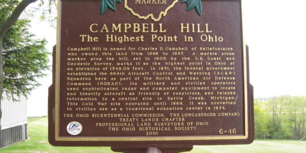
The property was previously part of the Bellefontaine Air Force Station. The land is currently owned by the Ohio Hi-Point Career Center. The Career Center not only makes the high point accessible to the public but also maintains it. That’s right, Campbell Hill is considered one of the best-kept state secrets in the country. Benches, a flagpole, and a big, upright plaque mark the point.
How does Campbell Hill compare?
Ohio may not be the largest state, but it still has more than 40,000 square miles. Campbell Hill, located in the state’s west-central region, is the highest peak, at 1,549 feet. The average elevation is 850 feet, with the Ohio River being the lowest point in the state at 455 feet above sea level.
Ohio’s terrain is divided into the Great Lakes Plains in the north, the Appalachian Plateau in the east, the Till Plains in the west, and the small Bluegrass Region in the south. The Till Plains region, known for its undulating hills and fertile farming, is home to the state’s highest peak.
Can you drive to Campbell Hill?
Yes, you can drive to the top of Ohio’s highest point. Because the location is on a community college campus, the road is paved, and the grounds are well-kept and manicured. Campbell Hill is a few miles east of the Bellefontaine city core.
If you intend to visit, attempt to do so during business hours to guarantee that the grounds are accessible to tourists. Admission to the high point is free, and parking is available nearby. Furthermore, Ohio’s highest point is ADA-accessible.
Where is Campbell Hill on a Map?
Campbell Hill, unlike many of the state’s highest points, is located amid the lively town of Bellefontaine. The highest point in Ohio is located northeast of Columbus, the state’s capital city.
Things To Do Near Campbell Hill
So, after admiring Campbell Hill’s beautiful college grounds, what do you do next? Depending on your interests, Bellefontaine (and the neighboring areas) have a lot to offer. For nature walks, visit the Big Darby Headwaters Nature Preserve. If you desire a little more outdoor experience, the Ohio Caverns provides caving chances.
Nearby camping options include Indian Lake State Park, which provides both camping and enjoyment. There are other private camping “resorts” nearby. If you enjoy museums, the Logan County History Center in Bellefontaine is a must-see. Finally, Bellefontaine has a busy downtown area with a diverse selection of restaurants, bars, and hotels.